Flood Watch & Warnings in Western New York This Week
Western New York is facing a significant weather event this week, with flood watches and flood warnings impacting communities from Buffalo to Batavia and beyond. As of early April 2026, residents across the region are being urged to monitor rising water levels, avoid flooded roadways, and prepare for additional rounds of heavy rain through the Easter holiday weekend. Here's everything you need to know about the current flood situation in WNY and how to stay safe.
Current Flood Watch and Flood Warning Status in Western New York
According to recent reports on the WNY flood watch, multiple flood alerts are currently active across the region:
- A flood watch was in effect until 8:00 p.m. Wednesday, covering small streams, creeks, some rivers, and localized urban and poor drainage areas throughout Western New York.
- A flood warning is in effect for Ellicott Creek until Thursday evening.
- A flood warning is in effect for Tonawanda Creek from the Niagara River east to Batavia, running through Saturday morning.
The distinction between a flood watch and a flood warning is critical: a watch means conditions are favorable for flooding to develop, while a warning means flooding is already occurring or is imminent. With both types of alerts active simultaneously, residents in affected areas should treat the situation with heightened urgency.
What's Driving the Flooding: Cold Fronts, Warm Air, and Heavy Rain
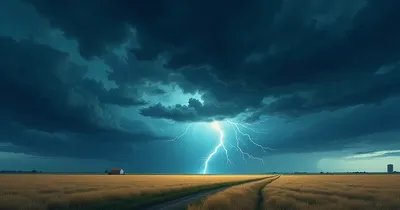
The flooding in WNY is the result of a combination of meteorological factors converging at once. A strong cold front pushing through the region Tuesday night is the primary driver, bringing with it powerful thunderstorms and heavy downpours. These intense rain bursts are embedded within broader rounds of showers and storms, making rainfall totals climb rapidly over a short period.
Compounding the problem is unseasonably warm air that has settled over the Great Lakes region ahead of the front. Temperatures earlier in the week surged well above normal for early April, with highs reaching into the upper 60s and low 70s. Warm air holds more moisture, which translates directly into heavier, more persistent precipitation when storms develop.
The saturated ground conditions from previous rainfall events have left little capacity for additional absorption, meaning runoff is flowing quickly into creeks, streams, and drainage systems — pushing waterways like Ellicott Creek and Tonawanda Creek toward or beyond their banks.
Day-by-Day Weather Forecast Through Easter Weekend
Understanding the full forecast timeline helps residents plan ahead and know when conditions will improve:
- Wednesday, April 1: Flood watch in effect until 8:00 p.m. Morning sprinkles tapering from south to north. Cool with a high of 48°F.
- Thursday (Passover begins): Warmer conditions return with scattered rain showers and some breaks in the clouds. High of 66°F. Flood warning continues for Ellicott Creek through Thursday evening.
- Friday: Breezy and warm with a few showers and possible thunderstorms. High of 68°F — well above the seasonal average.
- Saturday: The warmest day of the stretch, with a high of 72°F. Morning rain showers are expected to taper off into the afternoon. The Tonawanda Creek flood warning expires Saturday morning.
- Sunday (Easter): A significant shift arrives — breezy and considerably chillier with periods of rain gradually tapering later in the day. High of just 48°F, a drop of nearly 25 degrees from Saturday.
- Monday after Easter: The cold air fully settles in, with snow flurries possible on the hills. Mostly to partly sunny skies otherwise. High of 43°F.
The sharp temperature swing from Saturday's 72°F warmth to Sunday's 48°F and Monday's snow flurries illustrates just how powerful and fast-moving this cold front system is. Several rounds of rain and thunderstorms are expected to impact the region through Easter weekend before drier and cooler conditions take hold.
Flood Safety: What to Do During a Flood Watch or Warning
Whether you're under a flood watch or a flood warning, knowing how to respond can save your life and property. Here are the key safety actions recommended by emergency management officials:
- Never drive through flooded roads. Just six inches of fast-moving water can knock a person down; two feet of water can sweep away most vehicles. "Turn around, don't drown" is the rule that saves lives.
- Move to higher ground immediately if you live near a creek, stream, or low-lying area under a flood warning.
- Avoid walking through moving water. What looks like a shallow puddle can conceal a washed-out road or storm drain.
- Keep emergency supplies ready. Have a emergency flood preparedness kit on hand with flashlights, batteries, bottled water, and important documents in a waterproof bag.
- Monitor NOAA Weather Radio or local alerts for updates on flood warnings and watches in your area.
- If your basement floods, do not enter if there's any chance electrical systems have been compromised.
For households in flood-prone areas near Ellicott Creek or Tonawanda Creek, having a submersible sump pump and sandbags for flooding on hand before water rises is far better than scrambling for these items mid-storm.
Protecting Your Home During Heavy Rain and Flood Events
Beyond immediate safety, flooding events like this one in WNY are a reminder to take proactive steps to protect your home and property. Here's what homeowners can do before, during, and after a flood:
Before the Storm
- Clear gutters and downspouts of debris to ensure proper drainage away from your foundation.
- Install a battery backup sump pump — power outages during storms are common, and your primary pump won't help if the electricity goes out.
- Consider applying waterproof basement sealant to vulnerable walls.
- Move valuables and important documents to upper floors or sealed waterproof containers.
During the Storm
- Stay off the roads as much as possible, especially near creeks and low bridges.
- Keep a weather alert radio tuned in for real-time updates.
- Avoid using electrical appliances if your basement has taken on water.
After the Flood
- Use a wet dry vacuum for flooding to remove standing water quickly and prevent mold growth.
- Deploy industrial dehumidifiers to dry out affected areas before mold takes hold.
- Document all damage with photos for insurance claims before beginning cleanup.
Frequently Asked Questions About the WNY Flood Watch
What is the difference between a flood watch and a flood warning?
A flood watch means conditions are favorable for flooding — you should be prepared to act. A flood warning means flooding is already occurring or is imminent in the specified area. Flood warnings require immediate action, especially if you're in a low-lying area near a waterway like Ellicott Creek or Tonawanda Creek.
How long will the flood warnings be in effect in Western New York?
The flood warning for Ellicott Creek is in effect until Thursday evening. The flood warning for Tonawanda Creek (from the Niagara River east to Batavia) runs through Saturday morning. Conditions are expected to improve by Saturday afternoon as rain showers taper and the front moves through.
Is it safe to travel in WNY during the flood watch?
Travel should be minimized when flood watches and warnings are active. If you must travel, avoid roads near creeks, streams, and low-lying areas. Never drive through standing or moving water — the depth and current can be far more dangerous than they appear. Always heed road closure signs posted by local officials.
Will Easter Sunday be affected by flooding?
The flood warnings are expected to expire by Saturday morning (Tonawanda Creek) and Thursday evening (Ellicott Creek). By Easter Sunday, the primary concern shifts to heavy rain and breezy conditions with a high of 48°F rather than active flooding. However, waterways may remain elevated, so continue to avoid creek banks and flood-prone areas through the weekend.
What should I include in a flood emergency kit?
A basic flood emergency kit should include: bottled water (one gallon per person per day for at least three days), non-perishable food, a flashlight with extra batteries, a first aid kit, a battery-powered or hand-crank radio, important documents in a waterproof bag, cash, medications, and a change of clothes. A pre-assembled emergency preparedness kit can make preparation faster and simpler.
Conclusion: Stay Informed and Stay Safe This Easter Weekend
The ongoing flood watch and flood warnings across Western New York are a serious reminder that spring weather in the Great Lakes region can be both beautiful and dangerous within the same week. From near-record warmth this Saturday at 72°F to snow flurries on the hills by Monday, the dramatic weather pattern unfolding ahead of Easter weekend demands both awareness and preparation.
If you live near Ellicott Creek, Tonawanda Creek, or any other waterway in the Buffalo-Niagara region, stay current with the latest alerts through NOAA and local news sources. Review the latest updates on the WNY flood situation and have your emergency supplies ready. The best time to prepare is before the water rises — not after.
Remember: When in doubt, stay out. Floodwaters can rise rapidly and move with far more force than they appear. Your safety is always more important than any property or schedule.
Weather Alerts
Severe weather updates and forecasts delivered fast.
Sources
- recent reports on the WNY flood watch yahoo.com