Winter Storm Warning: Ice, Sleet Hit Midwest April 2026
As April begins, a powerful and dangerous winter storm system is sweeping across the upper Midwest, bringing a hazardous mix of freezing rain, sleet, ice, and snow to parts of Minnesota and Wisconsin. Winter storm warnings and ice storm warnings went into effect at midnight on April 1–2, 2026, catching many residents off guard during what is typically a transitional period between winter and spring. With ice accumulations up to half an inch possible in the hardest-hit areas, this storm is prompting urgent safety concerns — and it's not over yet. A round of severe thunderstorms is expected to follow the winter precipitation, with another bout of mixed precipitation returning Friday night into Saturday.
Winter Storm Warnings and Ice Storm Warnings: What's in Effect
According to KEYC News, a winter weather advisory and winter storm warning went into effect at midnight April 1–2 for parts of Minnesota and Wisconsin. These alerts are set to remain in place through noon on Thursday, April 2.
In the most severely impacted counties, ice storm warnings have been issued. These are not routine alerts — an ice storm warning means conditions are expected to be life-threatening and infrastructure-damaging. Here's what residents in the affected areas can expect:
- Ice storm warning zones: Ice accumulations of 0.25–0.50 inches, posing extreme hazards to roads, trees, and power lines.
- Winter storm warning zones: Ice accumulations of 0.10–0.25 inches, along with sleet and some snow accumulation.
- General advisory zones: Lighter accumulations of freezing rain and wintry mix, still enough to create dangerous travel conditions.
Even a quarter inch of ice can make roads virtually impassable and snap tree limbs. Half an inch of ice can bring down power lines and cause widespread, prolonged outages lasting days.
Timeline of the Storm: What to Expect and When
This storm system is unfolding in multiple phases, and understanding the timeline is critical for residents planning travel or preparing their homes. NBC26 has been tracking the full sequence of events:
- Wednesday evening, April 1: Precipitation began moving in after 4 p.m., initially falling as rain before transitioning to a wintry mix by midnight.
- Wednesday night – Thursday morning: The most dangerous phase of the storm, with freezing rain, sleet, and snow falling across warning areas. Ice accumulations building on untreated surfaces.
- Thursday morning – noon (April 2): Warnings remain in effect. Hazardous travel conditions persist across Minnesota and Wisconsin.
- Thursday afternoon: Warnings expire at noon, but the threat doesn't end — a chance for severe thunderstorms emerges, bringing the potential for damaging winds, large hail, and heavy downpours.
- Friday night – Saturday: Another round of mixed precipitation is expected, with Saturday wind gusts potentially reaching up to 40 mph.
This rapid transition from ice storm to severe thunderstorm potential within a single calendar day is highly unusual and underscores the volatile atmospheric pattern currently gripping the region.
Dangers of Ice Accumulation: What 0.50 Inches of Ice Actually Means
Many people underestimate the destructive power of freezing rain. Unlike snow, which can be plowed and shoveled, ice accumulation encases everything it touches — roads, sidewalks, vehicles, power lines, and tree branches — in a solid, slippery shell.
At the upper end of forecast accumulations (0.50 inches), the impacts can be severe:
- Roads: Become extremely dangerous even for four-wheel-drive vehicles. Black ice forms invisibly on pavement and bridges.
- Trees: A single ice-coated tree can hold hundreds of pounds of extra weight, leading to broken limbs and downed trees across roads and power lines.
- Power infrastructure: Ice-laden lines and poles can snap, causing widespread outages that may last several days, especially in rural areas.
- Walking surfaces: Even short trips to retrieve mail or check on a vehicle become hazardous. Falls on icy surfaces are a leading cause of winter injuries.
Emergency management officials across Minnesota and Wisconsin are urging residents to stay off roads during the warning period and to prepare for possible power outages.
Essential Supplies to Have on Hand During a Winter Ice Storm
If you're in the path of this storm or in a region prone to winter weather, now is the time to make sure your home and vehicle are stocked with the right gear. Being prepared before the ice forms is essential — once roads are coated, restocking becomes dangerous or impossible.
For your home:
- Ice melt (calcium chloride) — Works at lower temperatures than rock salt, ideal for freezing rain events.
- Emergency power outage kit — Flashlights, batteries, and backup lighting in case power goes down.
- Portable home generator — Provides backup power for heating, refrigeration, and communication during extended outages.
- Indoor emergency propane heater — A safe way to supplement heat if your furnace loses power. Always follow ventilation guidelines.
- Heavy-duty ice scraper and snow brush — Essential for clearing ice from vehicles before travel.
For your vehicle:
- Winter emergency car kit — Typically includes a blanket, jumper cables, traction aids, and first aid supplies.
- Traction boards for snow and ice — Helpful for getting unstuck from icy patches.
- Windshield deicer spray — Fast-acting and useful when you need to move quickly in freezing rain conditions.
After the Ice: Severe Thunderstorms and Weekend Flooding Risk
The end of the winter storm warnings Thursday at noon does not mean the weather hazards are over. As MLive reports, the pattern remains active well into the weekend with multiple additional threats:
Thursday afternoon — Severe Thunderstorms: The same atmospheric energy driving the winter storm will transition to fuel severe thunderstorm development by Thursday afternoon. Forecasters are watching for the potential of damaging winds, large hail, and heavy downpours. The abrupt shift from ice storm to severe thunderstorm conditions within hours is a hallmark of powerful spring-transitional weather systems.
Friday night into Saturday — Another Round of Precipitation: A second wave of precipitation is expected to impact the region Friday night into Saturday. Wind gusts on Saturday could reach up to 40 mph, compounding travel hazards and increasing the risk of additional power outages.
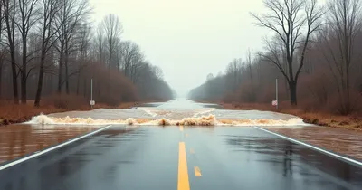
Flooding Concerns: With multiple rounds of rain, sleet, and melting ice expected through the weekend, rivers and streams across the region could see rising water levels. Residents in low-lying areas near waterways should monitor local flood alerts closely and be prepared to act quickly if river levels begin to climb.
Frequently Asked Questions About Winter Storm Warnings
What is the difference between a winter storm warning and an ice storm warning?
A winter storm warning is issued when a combination of hazardous winter weather — including heavy snow, blowing snow, sleet, and freezing rain — is expected. An ice storm warning is a more specific and often more dangerous alert, issued when significant ice accumulation from freezing rain (typically 0.25 inches or more) is expected. Ice storm warnings indicate a higher probability of power outages, fallen trees, and extremely dangerous travel conditions.
How long do winter storm warnings typically last?
Winter storm warnings are generally issued 12–36 hours in advance and can remain in effect for anywhere from a few hours to more than a day, depending on storm duration and intensity. In this case, the warnings issued at midnight on April 1–2 are set to expire at noon on April 2 — a 12-hour window covering the most intense phase of the storm.
Is it safe to drive during an ice storm warning?
In most cases, no. Ice storm warning conditions make roads extremely dangerous even for experienced drivers with four-wheel drive. Emergency management officials and state transportation departments consistently advise avoiding all non-essential travel during active ice storm warnings. If you must drive, reduce speed significantly, increase following distance, and avoid bridges and overpasses, which ice over before road surfaces.
How can I prepare for a power outage during an ice storm?
Before the storm: charge all devices, fill bathtubs with water (for flushing toilets), prepare alternative heating sources, stock up on non-perishable food, and locate flashlights and batteries. A portable home generator can be invaluable during extended outages. Never run a generator indoors or in a garage — carbon monoxide poisoning is a leading cause of storm-related deaths.
Why is freezing rain occurring in April?
Late-season winter storms are not uncommon in the upper Midwest. The region can see significant winter weather events into April and, occasionally, May. These events occur when cold Arctic air remains anchored at the surface while warmer, moist air overrides it at higher altitudes — the classic setup for freezing rain. April storms can sometimes be more intense than those in January because of the greater amount of atmospheric moisture available as temperatures warm.
Conclusion: Stay Informed, Stay Safe
This April 2026 winter storm is a serious reminder that dangerous winter weather doesn't adhere to a calendar. With ice storm warnings in effect for parts of Minnesota and Wisconsin, the potential for up to half an inch of ice accumulation, and a rapidly evolving threat that transitions from winter storm to severe thunderstorms and back to significant weekend precipitation, residents across the upper Midwest face a multi-day period of hazardous conditions.
The most important steps you can take right now are to stay off the roads during the warning period, ensure your home and vehicle are properly equipped, and keep a close eye on official weather alerts from the National Weather Service and local meteorologists. With another round of precipitation expected Friday night into Saturday — and wind gusts up to 40 mph — this weather pattern demands continued vigilance well beyond Thursday morning.
Monitor updates from trusted sources like KEYC News, NBC26, and MLive throughout the day, and always follow the guidance of local emergency management officials.
Weather Alerts
Severe weather updates and forecasts delivered fast.
Sources
- KEYC News keyc.com
- NBC26 nbc26.com
- MLive reports mlive.com