A dangerous, multiday tornado outbreak is actively tearing through the central and midwestern United States on April 17, 2026 — and it isn't over yet. With 37 preliminary tornado reports logged since Tuesday, April 14, simultaneous warnings across five states, and approximately 142,000 people under immediate life-threatening tornado warnings as of Friday afternoon, this event ranks among the most significant severe weather outbreaks of early spring 2026. Large, confirmed tornadoes are on the ground right now. If you're in the Midwest today, this is not a drill.
The Outbreak by the Numbers: What's Happened Since Tuesday
The current severe weather event began building Tuesday, April 14, when 31 tornado reports were recorded in a single day — predominantly across Iowa, Wisconsin, and Michigan. That figure alone would make Tuesday one of the more active tornado days of the year, but it was only the beginning. By Thursday evening, the cumulative three-day total had reached 37 preliminary tornado reports across the United States.
Preliminary tornado reports are logged by the Storm Prediction Center as events are called in by spotters, emergency managers, and automated systems. Not every report is confirmed as a full tornado after survey teams investigate — some are later classified as straight-line wind damage — but 37 reports in three days signals a persistent, organized severe weather pattern, not isolated storms.
Wednesday and Thursday saw the storm system reorganize, and by Friday morning it was clear the worst was still ahead. The atmosphere had not exhausted its instability. Quite the opposite: conditions were ripening for a dangerous Friday afternoon and evening across the Upper Midwest.
Friday's Peak: Warnings Across Five States Simultaneously
The outbreak reached a critical threshold on Friday afternoon. Tornado warnings were simultaneously issued across Missouri, Iowa, Illinois, Minnesota, and Wisconsin — placing roughly 142,000 people in the direct path of dangerous tornadoes as of approximately 5 p.m. ET.
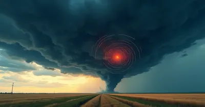
The most acute threat materialized in northwestern Illinois. The National Weather Service issued urgent "TAKE COVER NOW" life-safety messaging for the Freeport, Illinois area after a large, confirmed tornado was tracked on the ground moving through Jo Daviess and Stephenson counties. The tornado was moving east at approximately 25 mph, directly threatening the towns of Freeport and Lena. This is not a situation where residents had hours to prepare — at 25 mph, a tornado can cover a mile in under two and a half minutes.
For context on the Rochester, Minnesota area's specific warnings, see our coverage of the tornado watch issued for the Rochester region, and for First Alert Day details from regional broadcasters, KTTC's severe weather coverage has been tracking the system hour by hour.
Confirmed Tornadoes: Illinois and Wisconsin
Two tornado confirmations stand out from Friday's activity as representative of the outbreak's severity.
Jo Daviess and Stephenson Counties, Illinois
The large tornado confirmed moving through the northwestern Illinois corridor was not a brief touchdowns. NWS radar-confirmed rotation, and the life-safety language deployed — specifically the phrase "TAKE COVER NOW" — is language the Weather Service reserves for the most immediate, life-threatening situations. Freeport, a city of roughly 24,000 people, was directly in the storm's projected path when warnings were issued.
Avalon, Wisconsin
At approximately 6:09 p.m. on Friday, the NWS confirmed a tornado near Avalon, Wisconsin — roughly 10 miles southeast of Janesville. Reports from the Walworth County area documented snapped and uprooted trees along with home damage. Beyond the tornadoes themselves, severe thunderstorm warnings in parts of Wisconsin included threats of baseball-sized hail and wind gusts reaching 70 mph — hazardous even in the absence of tornadoes.
Flooding added another layer of danger. WIS 241 in Franklin, Wisconsin was closed due to high water levels at the Root River, illustrating the compound nature of these events. Tornado outbreaks are rarely just about tornadoes — they arrive embedded in broader storm systems capable of producing flash floods, large hail, and damaging straight-line winds simultaneously.
Why the Atmosphere Was So Explosive on April 17
AccuWeather Senior Meteorologist Dan Pydynowski put it plainly: "The atmosphere is primed for destructive storms across the central U.S." That statement deserves unpacking, because it reflects a specific set of atmospheric conditions that make April one of the most dangerous months of the year in America's heartland.
April sits at the intersection of competing air masses. Cold, dry air pushing down from Canada collides with warm, moisture-laden air surging north from the Gulf of Mexico. When a strong jet stream and an associated dryline — the boundary where dry western air meets humid southern air — are present, the result is an environment with the three ingredients tornadoes need: wind shear, lift, and instability.
The highest risk zone on Friday extended from eastern Kansas through parts of the Upper Midwest, tracking the corridor where these atmospheric collisions were most intense. The fact that this system sustained itself across multiple days — from Tuesday through Friday — indicates a slow-moving upper-level trough kept refreshing instability across the region rather than clearing out after a single day's activity.
Forecast maps show additional severe storm potential continuing into the weekend, meaning residents in the region should not assume Friday's peak signals an all-clear.
What to Do Right Now: Tornado Safety Essentials
With active warnings across multiple states, the most valuable thing this article can offer is clear, actionable safety guidance. The following is consistent with National Weather Service protocols:
- If a tornado warning is issued for your location, act immediately. A watch means conditions are favorable; a warning means a tornado has been confirmed or indicated by radar. The time to move is now, not after you see it.
- Go to the lowest floor of a sturdy building, to an interior room. Basements are ideal. Interior bathrooms, closets, and hallways on the lowest level are the next best option. Stay away from windows.
- Do not shelter under highway overpasses. Despite persistent myths, overpasses offer no protection and can actually funnel debris-laden wind at dangerous speeds.
- If you are in a mobile home, leave immediately. No mobile or manufactured home is safe in a tornado, even those with tie-downs. Identify a nearby sturdy structure before severe weather season begins.
- Have a battery-powered weather radio or a reliable alert app. A battery powered weather radio remains the gold standard for receiving alerts during power outages when your phone may have no signal or dead battery.
- Prepare a go-bag and emergency kit. A emergency tornado survival kit with water, first aid supplies, a flashlight, and documents should be accessible quickly. Keep a emergency hand crank flashlight and first aid kit in your shelter area.
- Protect your head. Flying and falling debris causes the majority of tornado fatalities. A bicycle helmet worn during shelter can significantly reduce head injury risk.
For families with young children or elderly relatives, this is also a good moment to review your household emergency plan — where you'll go, how you'll communicate, and how you'll reunite if separated.
Analysis: What This Outbreak Reveals About Spring 2026's Tornado Pattern
Thirty-seven tornado reports in three days is significant, but context matters. The 2011 Super Outbreak produced 362 confirmed tornadoes in 48 hours across 21 states. The April 2026 event is not in that category — yet. What's notable is the geographic persistence and the Friday peak timing, which caught millions of people in populated corridors of Illinois and Wisconsin at a particularly active time of day.
Tornadoes occurring in the late afternoon and evening hours are more dangerous from a life-safety standpoint for two reasons: atmospheric instability peaks in the mid-to-late afternoon as surface heating maximizes, and tornadoes after dark are dramatically harder to see. The Avalon, Wisconsin tornado confirming at 6:09 p.m. sits near the transition to the evening window — where visibility decreases and reliance on radar-based warnings becomes total.
The multiday nature of this outbreak also raises a question that climate scientists have been examining with increasing interest: whether prolonged severe weather setups are becoming more common. Research published in recent years suggests that while the total number of tornado days per year has remained relatively stable, the clustering of tornadoes into large, multiday outbreaks may be intensifying. A single day with 31 tornado reports followed by a multi-state warning event two days later fits that pattern. This is an area of active scientific inquiry, not settled consensus, but it's a trend worth watching as the 2026 season unfolds.
From a practical standpoint, what this outbreak reveals is that storm prediction has never been better — the NWS issued tornado watches and warnings well ahead of confirmed touchdowns — but public response to those warnings remains inconsistent. Every time an outbreak of this magnitude passes, the post-event analysis includes cases of people who received warnings and did not take shelter. The warnings worked. The life-threatening language was explicit. The gap is behavioral, not meteorological.
Frequently Asked Questions
How long will this tornado outbreak last?
The active severe weather window for this outbreak is centered on Friday afternoon through Friday night, April 17, 2026. Forecast data suggests residual severe storm potential continuing into the weekend across portions of the Midwest. The most intense phase of the outbreak — with the greatest tornado probability and the largest geographic coverage of warnings — is occurring Friday. Residents in affected states should continue monitoring NWS forecasts through Saturday.
What's the difference between a tornado watch and a tornado warning?
A tornado watch means atmospheric conditions are favorable for tornado development in the watch area. You should know your shelter plan and stay aware of conditions. A tornado warning means a tornado has been confirmed on the ground or strongly indicated by Doppler radar. You should take shelter immediately. When the NWS says "TAKE COVER NOW," that language specifically accompanies the most dangerous, confirmed or imminent tornado situations — it's not routine warning language.
Why did so many tornadoes happen in April specifically?
April falls in the heart of what meteorologists call "tornado season" in the central United States, though tornadoes can occur any month of the year. April's volatility comes from the clash of warming surface temperatures — driven by longer days and stronger sun — against cold air masses that still dominate the northern tier of the country. The jet stream is typically at its most active and positioned favorably to provide the wind shear that gives tornadoes their rotation. The combination of Gulf moisture surging northward and cold continental air creates the unstable, shear-rich environment severe storms need.
Is baseball-sized hail actually dangerous?
Yes, severely so. Baseball-sized hail measures approximately 2.75 inches in diameter and falls at speeds exceeding 100 mph. It can cause fatal injuries to people caught outdoors, shatter car windshields, punch holes in roofs, and destroy crops. Even golf ball-sized hail (1.75 inches) is large enough to cause serious injury and significant property damage. When severe thunderstorm warnings include baseball-sized hail, they carry the same urgency as tornado warnings for anyone outdoors or in a vehicle.
How can I receive tornado warnings if I lose power?
A NOAA weather radio battery powered receiver is the most reliable option — these devices broadcast continuous NWS alerts and can be set to alarm automatically for your county. Many models also include a hand-crank option. Wireless Emergency Alerts (WEA) are pushed to cell phones automatically when warnings are issued, but these require cellular service, which can be disrupted during severe storms. A solar powered emergency radio provides additional redundancy during extended power outages.
Conclusion: This Outbreak Isn't Over
The April 2026 multiday tornado outbreak is a serious, ongoing severe weather emergency. Thirty-seven tornado reports since Tuesday, confirmed large tornadoes on the ground in Illinois and Wisconsin, 142,000 people under life-threatening warnings as of Friday afternoon, and a meteorological pattern that hasn't fully exhausted itself — these are not statistics to skim past. They describe real danger, in real communities, right now.
The forecasting infrastructure performed: watches and warnings went out in advance, meteorologists livestreamed the event to provide real-time context, and emergency messaging was explicit and urgent. The variable in every severe weather event is whether people act on those warnings. The NWS does not say "TAKE COVER NOW" for routine situations. When that language appears for your location, the correct response is immediate shelter, not deliberation.
If you are in Missouri, Iowa, Illinois, Minnesota, or Wisconsin as of the afternoon and evening of April 17, 2026, remain weather-aware through tonight. Keep a NOAA weather radio within reach, know your shelter location, and do not wait to see a tornado before you move. Spring 2026 has already demonstrated that this region's severe weather season is underway in earnest.