Friday afternoon in Indianapolis started like any other spring day — until the National Weather Service changed that in an instant. A tornado warning swept across portions of northern Marion County and southeastern Hamilton County on April 25, 2026, sending residents scrambling for cover and setting off outdoor warning sirens across the metro area. The warning, which targeted Fishers and northeast Indianapolis specifically, expired at 5:15 p.m. without any confirmed tornado touchdowns — but the event was a sharp reminder that severe weather in central Indiana demands to be taken seriously, every single time.
Here's a complete breakdown of what happened, why it escalated so quickly, and what Indianapolis-area residents should know heading into the remainder of spring storm season.
What Happened: The April 25 Tornado Warning in Fishers and Northeast Indianapolis
A line of severe storms moved across central Indiana on Friday afternoon, prompting the NWS Indianapolis office to issue a tornado warning for Fishers and portions of northeast Indianapolis. The warning covered northern Marion County and southeastern Hamilton County — a densely populated swath of the metro that includes some of Indiana's fastest-growing suburbs.
The warning triggered Hamilton County's outdoor siren system, which activates automatically when the NWS issues a tornado warning or when trained spotters or public safety personnel report a funnel cloud in the area. Video circulating online captured the moment tornado sirens blared across Indianapolis, underscoring just how jarring the warning felt to residents who were caught off-guard mid-afternoon.
Forecasters issued a pointed safety message alongside the warning: heavy rain could easily hide a tornado from view, meaning residents should not wait to see a funnel cloud before taking shelter. The instruction was clear — go to a basement or interior room on the lowest floor immediately.
By 5:15 p.m., the warning had expired. The Fishers Fire Department posted on Facebook confirming the all-clear, and no confirmed tornado touchdowns were reported. But the story didn't end there — severe thunderstorm warnings remained in effect across the metro even after the tornado threat passed, with radar indicating potentially damaging wind gusts that continued to pose a real risk to property and safety.
Why the Warning Escalated So Fast — And Why That's the Point
One of the most disorienting aspects of this event for many residents was the speed of escalation. The warning appeared to come and go within roughly an hour, leading some to question whether it was an overreaction. That framing misunderstands how tornado warnings work — and why the system is designed to move fast.
Tornado warnings are not issued when a tornado has already touched down and been confirmed on the ground. They're issued when radar signatures — specifically rotation in a thunderstorm's mesocyclone — indicate conditions are favorable for tornado development. The NWS does not wait for visual confirmation when radar shows a credible threat. That approach saves lives precisely because tornadoes can go from formation to destruction in minutes.
The spring of 2026 has been particularly active for severe weather across the central United States. A PDS Tornado Watch — a rare, particularly dangerous situation designation — was issued for six states earlier in April 2026, and the broader storm pattern affecting the Midwest has kept meteorologists on high alert. Central Indiana sits in a geographic position where warm, moist air from the Gulf meets cold, dry air from the Rockies — the classic recipe for rotating supercell thunderstorms.
The April 25 storm system moved quickly, which explains both the rapid warning issuance and the relatively fast expiration. Fast-moving storm lines can produce brief, intense tornado threats — what meteorologists sometimes call "spin-up" tornadoes — that are difficult to track and even harder to see in heavy rain. The NWS's caution was entirely warranted.
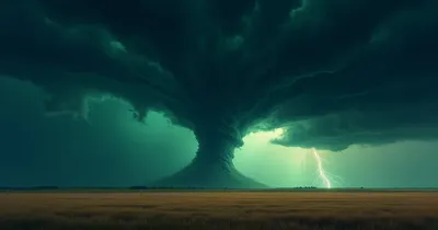
The Hidden Danger: Rain-Wrapped Tornadoes
Forecasters specifically warned residents that heavy rain could obscure a tornado — and that warning deserves more attention than it typically gets. Rain-wrapped tornadoes are among the most dangerous weather events precisely because they're nearly invisible until they're on top of you.
In a classic, photogenic tornado, the funnel is clearly visible against the sky. Rain-wrapped tornadoes form within or adjacent to heavy precipitation, making them nearly impossible to see with the naked eye. Residents who step outside to "look for the funnel" before deciding whether to take shelter are taking a serious and unnecessary gamble. This is exactly why the NWS instructs people to act on the warning, not on what they can see through their window.
The April 25 event occurred in an area with significant development density — Fishers consistently ranks among the fastest-growing cities in the United States, and northeast Indianapolis is built up with residential neighborhoods, retail corridors, and commercial centers. A rain-wrapped tornado in that environment, even a brief EF0 or EF1, would cause significant damage and potentially casualties.
Storm activity in the region has also caused problems beyond Indiana. Tornadoes in North Texas killed two people earlier this season, and the Ozarks region has dealt with historic tornado events this spring as well. The April 25 Indianapolis warning fits into a broader pattern of elevated severe weather risk across the central and southern United States.
How Indianapolis-Area Warning Systems Performed
The April 25 event offered a real-world test of the metro area's emergency communication infrastructure — and by most accounts, it worked as designed.
Hamilton County's outdoor warning sirens activated promptly when the NWS issued the tornado warning, consistent with the county's policy of triggering sirens for any NWS-issued tornado warning, regardless of whether a funnel has been visually confirmed. That policy is the right call. Waiting for visual confirmation before activating sirens would defeat the purpose of having a warning system at all.
The Fishers Fire Department's use of Facebook to communicate the all-clear at 5:15 p.m. reflects a modern reality of emergency communications: social media has become a primary channel for real-time public safety updates, particularly for younger demographics who may not have a weather radio. That said, social media has real limitations during active weather events — connectivity can be unreliable, and misinformation spreads quickly.
Residents were specifically encouraged to use NOAA Weather Radio or the county emergency app for official updates. A dedicated NOAA all-hazards weather radio remains one of the most reliable tools for receiving emergency alerts, because it doesn't depend on cellular networks or internet connectivity that can become congested or fail during major weather events. Smartphone-based Wireless Emergency Alerts (WEA) are useful, but they're a supplement to a dedicated weather radio, not a replacement.
What the Ongoing Thunderstorm Warnings Meant for Residents
When the tornado warning expired at 5:15 p.m., the threat didn't simply end — it evolved. Severe thunderstorm warnings remained in effect across the Indianapolis metro, with radar indicating potentially damaging wind gusts continuing to push through the area.
This is a distinction that matters. A tornado warning represents the highest level of immediate threat, but severe thunderstorm warnings are not benign. Straight-line winds from severe thunderstorms can exceed 70 or 80 mph in extreme cases, enough to topple trees, damage roofs, shatter windows, and down power lines. The same "shelter in place" mentality that applies to tornado warnings is appropriate during severe thunderstorm warnings, particularly for anyone near large trees, vehicles, or temporary structures.
Forecasts indicated that Indiana faced continued severe weather risk beyond the April 25 event, suggesting that central Indiana residents should remain prepared throughout the spring season rather than treating each individual storm as an isolated incident.
What This Means: The Bigger Picture for Indianapolis Storm Season
The April 25 tornado warning is not an outlier — it's a data point in a trend. Central Indiana has historically been considered peripheral to "Tornado Alley," the swath of the Great Plains most associated with severe tornado activity. But climate patterns and improved meteorological understanding have led researchers to identify an expanding severe weather corridor that increasingly includes Indiana, Ohio, and Kentucky.
Fishers and northeast Indianapolis represent exactly the kind of high-density suburban growth that amplifies the consequences of severe weather events. When communities develop rapidly, more people and structures occupy land that was previously open. That doesn't make tornadoes more frequent, but it does make each event potentially more consequential.
The April 25 event also illustrates the psychological challenge of repeated warnings that don't result in confirmed tornadoes. There's a real risk of warning fatigue — residents who shelter during multiple warnings that expire without touchdowns may gradually become less responsive to future warnings. This is a documented phenomenon, and it's dangerous. Every warning that expires without a confirmed tornado should be understood as the system working correctly, not as a false alarm.
Emergency managers in Hamilton and Marion counties have invested in multiple communication channels precisely because different residents rely on different information sources. The combination of outdoor sirens, Wireless Emergency Alerts, NOAA radio, and social media provides layered redundancy. Residents who rely on only one channel are more vulnerable to gaps in that channel's coverage.
For those looking to build out a proper home weather preparedness kit, a quality hand-crank emergency weather radio is an essential investment, alongside a tornado emergency preparedness kit stored in or near your basement shelter area.
Frequently Asked Questions: Indianapolis Tornado Warning, April 25, 2026
Was there an actual tornado on April 25, 2026 in Indianapolis?
No confirmed tornado touchdowns were reported. The NWS issued a tornado warning based on radar-indicated rotation within a storm system moving through northern Marion County and southeastern Hamilton County. The warning expired at 5:15 p.m. without any verified tornado contact with the ground. The absence of a confirmed touchdown does not mean the warning was unnecessary — it means the system worked, either by preventing a tornado from forming or by warning residents before one could cause harm.
Why did sirens go off in Hamilton County during the storm?
Hamilton County activates its outdoor warning sirens automatically when the National Weather Service issues a tornado warning for the county, or when trained spotters or public safety personnel report a funnel cloud. The sirens activated on April 25 because the NWS issued a tornado warning — that is exactly when sirens are supposed to sound. Outdoor sirens are designed to alert people who are outside; they are not intended to be heard clearly inside buildings with windows closed.
What areas were covered by the tornado warning?
The warning covered portions of northern Marion County and southeastern Hamilton County, with Fishers specifically identified as a primary area of concern. Fishers is a city of roughly 100,000 residents located north of Indianapolis proper and is one of Indiana's largest cities by population.
What should I do if a tornado warning is issued and I can't see any storm?
Take shelter immediately, regardless of what you can see outside. Forecasters explicitly warned during the April 25 event that heavy rain could hide a tornado from view. Rain-wrapped tornadoes are common in Indiana storm systems. The NWS bases tornado warnings on radar data showing rotation, not on visual confirmation of a funnel cloud. If a warning is issued for your location, go to your basement or an interior room on the lowest floor, away from windows, and stay there until the warning expires.
Are severe thunderstorm warnings as serious as tornado warnings?
Tornado warnings indicate a more immediate and specific threat of tornado activity, but severe thunderstorm warnings should not be taken lightly. After the April 25 tornado warning expired, severe thunderstorm warnings remained in effect across the Indianapolis metro, with radar showing conditions favorable for damaging wind gusts. Winds from severe thunderstorms can exceed 70 mph, causing serious structural damage and posing real dangers to anyone outdoors or in a vehicle. When a severe thunderstorm warning is issued, stay indoors, away from windows, and away from large trees.
Conclusion: Stay Ready, Not Reactive
The April 25 tornado warning in Fishers and northeast Indianapolis resolved without the worst-case outcome — and that's good news. But the event is a useful prompt for central Indiana residents to assess their own preparedness before the next storm system arrives. Spring 2026 has been an active severe weather season across the region, and the meteorological conditions that produce tornado-warned storms in Indianapolis don't become less common as the season progresses.
The warning system did what it was designed to do on Friday afternoon. The outdoor sirens activated, the Fishers Fire Department communicated clearly through social media, and the NWS issued and expired the warning based on real-time radar data. Residents who took shelter and waited for the all-clear made the right call.
The broader lesson is one of consistent preparedness rather than reactive scrambling. Knowing where your shelter location is before the sirens sound, having a NOAA weather radio in your home, and understanding the difference between a watch and a warning are not complicated preparations — but they make a significant difference when minutes matter. Central Indiana's storm season is not over, and the next warning could come with less margin for hesitation.